|
Selling the WORLD One GARMIN GPS at a time! NUNCA
TE PIERDAS OTRA VEZ. GPS QUE UTILIZA LA MAS AVANZADA TECNOLOGIA SATELITAL, PARA INDICARLE SU UBICACION EXACTA EN CUALQUIER
LUGAR DEL MUNDO!!!
QUE ES GPS ???
El sistema GPS (Global Positioning System) o Sistema
de Posicionamiento Global es un sistema compuesto por una red de 24 satélites denominada NAVSTAR, situados en una órbita a
unos 20.200 km. de la Tierra, y unos receptores GPS, que permiten determinar nuestra posición en cualquier lugar del planeta,
de día o de noche y bajo cualquier condición meteorológica. La red de satélites es propiedad del Gobierno de los Estados Unidos
de América y está gestionado por su Departamento de Defensa (DoD).
COMO FUNCIONA EL RECEPTOR???
Cada satélite procesa dos tipos de datos: las Efemérides
que corresponden a su posición exacta en el espacio y el tiempo exacto en UTM (Universal Time Coordinated), y los datos del
Almanaque, que son estos mismos datos pero en relación con los otros satélites de la red, así como también sus órbitas. Cada
uno de ellos transmite todos estos datos vía señales de radio ininterrumpidamente a la Tierra.
Cuando nosotros encendemos nuestro receptor GPS portátil y apuntamos la antena hacia el cielo, empezamos a captar y recibir
las señales de los satélites (el receptor GPS no envía ninguna señal de radio, sólo las recibe), empezando por la más fuerte,
de manera que puede empezar a calcular la distancia exacta hasta ese satélite, así como saber dónde buscar los demás satélites
en el espacio.
Una vez que el receptor GPS ha captado la señal de, al menos, tres satélites, entonces puede conocer la distancia a cada
uno de ellos y puede calcular su propia posición en la Tierra mediante la triangulación de la posición de los satélites captados,
y nos la presenta en pantalla como Longitud y Latitud. Si un cuarto satélite es captado, esto proporciona más precisión a
los cálculos y se muestra también la Altitud calculada en pantalla.
Mas Gps y accesorios !!
     
|
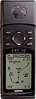
| Garmin GPS 12 |
The GARMIN GPS 12 Personal Navigator: an affordable 12 parallel channel handheld for outdoor
adventurers who want a basic, hard-working 12-channel GPS, but who don't want to spend a bundle. Based on the popular GPS
12XL, the GPS 12 offers outdoor enthusiasts an entry-level way to gain the power and performance of a 12-channel receiver
with fast satellite acquisition in the toughest conditionseven in heavy tree cover. INCLUYE BASE
DE DATOS DE TODA AMERICA, CIUDADES, PUEBLOS, RIOS, MARES, CARRETERAS, LAGOS, COSTAS, ETC., PUEDE CONECTARSE A UNA PC USANDO
UN CABLE SERIAL (OPCIONAL), CARACTERISTICAS COMPLETAS EN:
|
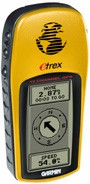
| Garmin E-Trex Camo |
The most recent addition to the eTrex Personal Navigator series is the camouflaged eTrex. Concealed
beneath the new sportsman-friendly pattern is a compact, waterproof handheld GPSamong the smallest on the market. Measuring
roughly 4"x 2"x1" and weighing less than 6 oz., this personal navigator is packed with all of the features of the original
eTrex, plus a hunting and fishing calculator that provides optimal times of day to plan your sporting excursions. INCLUYE
BASE DE DATOS DE TODA AMERICA, CIUDADES, PUEBLOS, RIOS, MARES, CARRETERAS, LAGOS, COSTAS, ETC.,
|
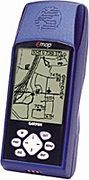
| Garmin E-map |
Here's another reason to toss out those paper maps: the eMap. It's the size of a small,
flat calculator, contains a 12 parallel channel GPS receiver, and weighs a mere six ounces. Even with its compact style, the
eMap boasts an extra-large display for showing even more map data and the same power you've come to expect from GARMIN handheldseven
while operating for up to 12 hours on just two AA batteries.
The eMap features an internal basemap containing information
on North and South America including state and country boundaries, lakes, rivers, streams, airports, cities, towns, coastlines,
and U.S., state, and interstate highways. In addition, the eMap provides exit information for the federal interstate highway
system. With the eMap, you will know when you are near services such as food, lodging, and service stations.
GPS GARMIN EMAP, NUEVO, EN SU CAJA, INCLUYE MANUAL, MUY RAPIDO, PUEDE FIJAR LA POSICION EXACTA
EN TAN POCO COMO 15 SEGUNDOS, INCLUYE MAPAS DETALLADOS DE E.U.A. (CALLES, RESTAURANTES, CARRETERAS, LAGOS, AEROPUERTOS, ETC.)
Y LAS CARRETERAS MAS IMPORTANTES DE MEXICO Y CANADA. 1 yr warranty / 1 año de garantia
|
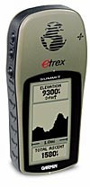
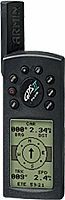
| Garmin E-Trex Summit |
The eTrex Vista
combines a basemap of North and South America, with a barometric altimeter and electronic compass. The compass provides bearing
information while you're standing still and the altimeter determines your precise altitude. The Vista is also designed to
provide precise GPS positioning using correction data obtained from the Wide Area Augmentation System (WAAS). This product
will provide position accuracy to less than three meters when receiving WAAS corrections. INCLUYE BASE DE DATOS DE TODA AMERICA,
CIUDADES, PUEBLOS, RIOS, MARES, CARRETERAS, LAGOS, COSTAS, ETC., $
|
| Garmin E-Trex Legend |
With the eTrex Legend, GARMIN has loaded a full basemap of North and South America into one small unit. The Legend is also designed
to provide precise GPS positioning using correction data obtained from the Wide Area Augmentation System (WAAS). This product
will provide position accuracy to less than three meters when receiving WAAS corrections. INCLUYE
BASE DE DATOS DE TODA AMERICA, CIUDADES, PUEBLOS, RIOS, MARES, CARRETERAS, LAGOS, COSTAS, ETC., $
|
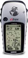
| Garmin E-Trex Vista |
The eTrex Vista combines a basemap of North and South America, with a barometric altimeter and electronic compass. The compass
provides bearing information while you're standing still and the altimeter determines your precise altitude. The Vista is
also designed to provide precise GPS positioning using correction data obtained from the Wide Area Augmentation System (WAAS).
This product will provide position accuracy to less than three meters when receiving WAAS corrections. GPS ETREX VISTA CON BRUJULA Y ALTIMETRO, 24MB DE RAM PARA DESCARGAR MAPAS DE LOS CD'S MAPSOURCE (LOS VENDO
POR SEPARADO), TIENE UNA BASE DE DATOS CON LAS CARRETERAS CON LAS MAS IMPORTANTES CARRETERAS Y CIUDADES DE AMERICA, EL MENU
PUEDE CAMBIARSE A DIFERENTES IDIOMAS INCLUYENDO EL ESPAÑOL, INCLUYE MANUAL CORREA Y CABLE SERIAL, CARACTERISTICAS COMPLETAS
EN WWW.GARMIN.COM, 1 yr warranty / 1 Año de garantia. $
|
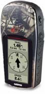
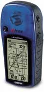
| Garmin E-trex |
Inside the eTrex, you will find the proven performance of a 12 parallel
channel GPS receiver that will run for 18 hours on just two AA batteries. No need to worry about dense tree canopy with this
unit, the eTrex will continue to maintain a tight satellite lock even while operating in forest-like conditions. The eTrex
will store up to 500 user waypoints with graphic icons and boasts GARMIN's exclusive TracBack feature that will reverse your
track log and help you navigate your way back home. In addition, the eTrex uses animated graphics that will help you identify
your marked waypoints quickly and easily. NUEVO, EMPACADO, GARMIN consigue con el eTREX uno de los GPS portátiles
más pequeños del mercado. Pantalla FTSN con 4 niveles de grises, resolución de 128x64 pixeles, receptor de 12 canales, atractivo
diseño compacto y robusto, así como un peso y tamaño reducido que no por ello limita sus excelentes prestaciones. Además
el eTREX destaca por su facilidad de manejo con solo 5 teclas laterales , haciendo posible que las funciones más frecuentes
como creación de rutas y waypoints, sean muy fáciles de realizar. Pantallas gráficas que informan sobre datos de navegación,
ploteo de huella o compás, son algunas de sus funciones más destacables. Incorpora también entrada y salida de datos, alarma
de llegada, posibilidad de asignar iconos a los waypoints, función TracBack y resistencia al agua según norma IEC-529, IPX7
(30 minutos a 1 metro prof.)
El eTREX es el primer GPS de GARMIN que funciona con solo 2 pilas alcalinas. Accesorios
opcionales, adaptador alimentación mechero, cable para PC, funda y DGPS. 1 yr warranty / 1 año de garantia. $
|
| Garmin II Plus |
Hot on the heels of the revolutionary GPS II comes GARMIN's high-powered
switchable handheld: the GPS II Plus. Featuring an impressive 12 parallel channel receiver for quick satellite acquisition
and enhanced reception, the GPS II Plus is designed to track any over-the-road journey and offroad adventure you have in mind.
GARMIN's newest compact GPS features a state-of-the-art two-way screen display for vertical or horizontal orientationwhich
makes it easy to go from your vehicle to the hiking trail.
With an external antenna for impressive reception, the GPS II Plus also
boasts dedicated zoom keys, waypoint symbols, diagonal panning, auto start/stop trip timer, and average and maximum speed
recordings. Just four AA batteries will provide up to 24 hours of accurate tracking and precise navigation.
Now the same pinpoint guidance used by pilots the world over is
conveniently available to adventurers, regardless of their transportation means: 4x4, ATV, bicycle, motorcycle, snowmobile,
boat, or on foot. INCLUYE BASE DE DATOS DE TODA AMERICA, CIUDADES, PUEBLOS, RIOS, MARES, CARRETERAS, LAGOS, COSTAS, ETC.,
1 yr warranty / 1 Año de garantia. $
|
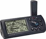
| Garmin III |
For today's traveler on the go, the answer to cumbersome paper maps has finally arrived. GARMIN's
compact, powerful GPS III will guide you safely and accurately from intersection to intersection or even city to city, anywhere
in the world, any time of day, in any weather. This affordable portable includes millions of miles of highways, interstates,
railroads, rivers, and shorelines to show you just where you stand.
Featuring GARMIN's hefty 12 parallel channel receiver for quick satellite aquisition and lock-on,
the GPS III calculates your position and displays it on a real-time moving map, as well as provides crucial travel information,
including speed, time and distance to destination. There's also a handy trip odometer, compass bearing, and average and maximum
speed readings. Additionally, the software is designed for superb ease-of-use, and the display can be configured to show only
what you want to see.
| |
|
GPS III MARCA GARMIN, NUEVO, INCLUYE BASE DE DATOS DE TODA AMERICA, CIUDADES, PUEBLOS, RIOS, MARES,
CARRETERAS, LAGOS, COSTAS, ETC., 1 yr warranty / 1 Año de garantia. $ |
|
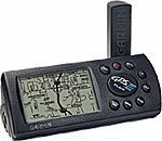
| Garmin III Plus |
GARMIN's new GPS III Plus offers cartographic capabilities formerly found
only in high-end automotive navigation and marine chartplotting units. Simply plug it into a PC and download an extra 1.44
MB of map data from GARMIN's line of MapSource CD ROM's to give you instant detailed maps.
Whether you're cruising the streets or pounding the waves, GARMIN has
the maps you need. Choose the "U.S. Roads and Recreation" CD for city street level detail and even inland marine features
such as lake and river shorelines, boat ramp and marina locations. Other CD's give you worldwide coverage of coastlines, including
a database of coastal cities, navaids and inland roads.
Even without additional cartography, the basemap in the GPS III Plus will
get you where you're going. More than 10,000 new towns have been added to the permanent basemap, as well as airport locations,
secondary roads in metro areas and even detailed exit information for the federal interstate highway system, including information
about available lodging, food and service stations.
| |
|
GPS III PLUS MARCA GARMIN, NUEVO, INCLUYE BASE DE DATOS DE TODA AMERICA, CIUDADES, PUEBLOS, RIOS,
MARES, CARRETERAS, LAGOS, COSTAS, ETC., 1 yr warranty / 1 año de garantia. $ |
|
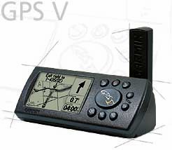
| Garmin V |
| The GPS V is one versatile navigator
that delivers automatic routing, detailed mapping and WAAS capability all in a compact handheld GPS. It comes with the MapSource
City Select CD, which gives you access to detailed street-level maps with locations of restaurants, hotels and other services. Use the GPS
V to look up a location and it will automatically calculate a route and guide you to your destination with turn-by-turn directions
and audible beeps that alert you to upcoming turns. You can even switch the display from horizontal, for mounting on a bike
or a vehicle dash, to vertical for handheld use.
Limited Quantities In-Stock - Cantidades Limitadas
ordena HOY!!! Mira el video para una demostración.
NUEVO, INCLUYE BASE DE DATOS DE TODA AMERICA, CIUDADES, PUEBLOS, RIOS, MARES, CARRETERAS, LAGOS, COSTAS,
ETC., 1 yr warranty / 1 Año de garantia. $ |
|
|
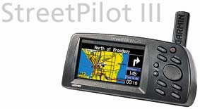
| Garmin Street Pilot III |
Imagine an over-the-road 'co-pilot' creating a route to get you to your
destination and then providing clear, accurate, voice-prompted turn-by-turn directions. This traveling companions full-color
LCD will show you locations of all the nearest highway exits, gas stations, restaurants, ATMs, hospitals, and rest areasplus
much more.
Meet the StreetPilot
IIIthe latest in affordable, portable satellite navigation for your car or truck.
The simple, intuitive menus offer access to the shortest and fastest routes,
turn directions, and estimated time of arrival at your intended destination. Along the way, the StreetPilot III provides automated
voice prompts, alerting the driver to necessary turns, distance to upcoming turns, course deviation, and distance to final
destination.
The StreetPilot III comes with MapSource City Navigator CD-Rom and everything
you need to download street-level mapsets from your PC. Then, just place the portable system on the dash of any vehicle, and
enjoy stress-free driving and peace of mindwithout any costly service charges or hook-up fees.
Please note: The StreetPilot III will be initially available in
the America version only. The StreetPilot III Atlantic version (covering Europe, Africa, and the Middle East) will be released
late 2001.
Garmin StreetPilot GPS ColorMap, UNO DE LOS MEJORES GPS MOBILES EN EL MERCADO, ES SU CAJA, NUEVO,
INCLUYE CABLE PARA ENCENDEDOR DEL COCHE, CABLE PARA PC, MANUAL Y EL GPS, CARACTERISTICAS COMPLETAS EN WWW.GARMIN.COM, 1 yr warranty / 1 Año de garantia. $
|